The Odyssey
Odd Encounters
BIO
Mid Swings
The Immigrant
The Son
The Grandson
Stop
Go
The Warnings
The
Reasons
The Why
The
Realities
The Rezoners
The Recovery
The Complaint
Platinum
109 & 113 Incidents
The Partners
The Engagement
The Slope Incidents
The Big Picture
The Bigger Picture
The Drawing
Zoning
Q's
De-Valuations Qs
Crumble
Q's
Regulations
Drainage
Lateral
Supports
Due Diligence
Interests
Medias
Questions |
|
|
|
|
|
|
The Auction
August 31, 2012
|
Signs were
posted for a Friday August 31, 4:00 P.M Real Estate Auction.
Rumors surfaced that auction signs were
not to be placed.
It worked out fine, as the
date and time is usually when our family attends the Annual
Italian Heritage Festival. So, said advertisement allowed us to be aware,
so we could attend the auction.
|
|
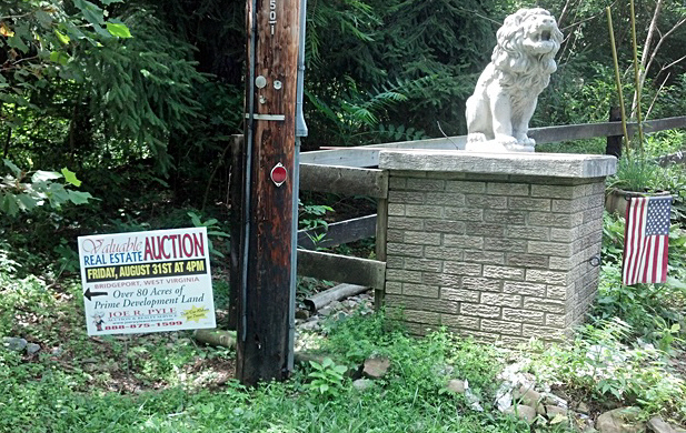 |
The Yellow Curved Arrow,
(mid-point), is the proximate
location of the Stone Lion and American Flag that are noted in the above
image.
|
|
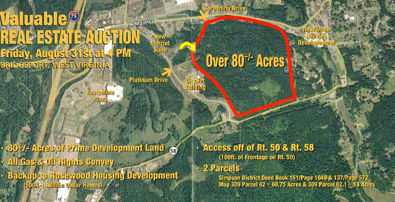 |
Said Highlighted 80 + or - Acres included Approximately
15 different landowners and a proximate 170 total acres, (150
Undeveloped).
Thus:
The
Outlined In Red, (80 + or - Acres), was wrong.
The
Highlighted in Orange, 74.75 Acres
was correct for
area for the highlighted 80 + or - Acres.
|
|
 |
The auctioneer flyer states two access points:
1); The listed
U.S Route 50 entrance possess inaccessible cliff like terrain. Additionally
an intersection at this area would exceed the dangerous accident prone
Emily Drive U.S 50 Intersection
2); The Auctioneer's listing of a
U.S Route 58 entrance is wrong, as it does not exist. (He corrects the Route 58 error and uses a squeeze play between
CityNet and the Tri-Partner's ever deteriorating slope as the only other
entrance).
Said area's in-accessibility is illustrated within the
Non-Selling Auction Price of $7,800 an acre.
A far cry form the
Tri-Partners Adjoining and Fully Accessible
$400,000 an Acre properties.
|

|

